
Quellensteg, Fürth
Quellensteg, 90762 Fürth, Germany
Quellensteg Fürth | Pegnitz & Cycling Path
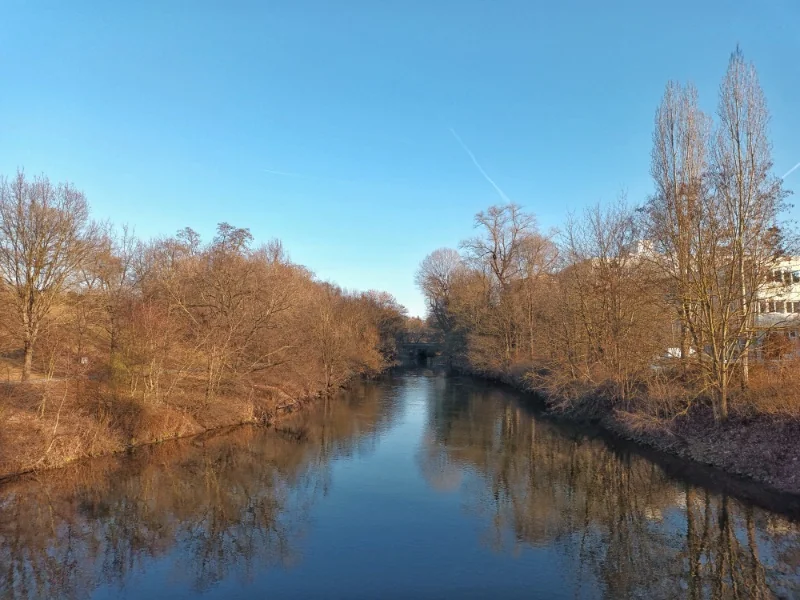
The Quellensteg in Fürth is not an ordinary bridge, but a quiet, green connection point between the city and the river landscape. Those who travel here experience the Pegnitz from its relaxed side: with a view of the riverside city, on paths towards Espan and Wiesengrund, and on a section of Fürth that is perfect for walks, small explorations, and cycling by the water. The bridge is particularly interesting for people who want more than just to get from A to B in the city, but are looking for a route that connects nature, movement, and orientation. The Quellensteg is a key component in the network of Fürth's healing springs and Pegnitz paths, making it much more than just a crossing over the river. ([fuerthwiki.de](https://www.fuerthwiki.de/wiki/index.php/Quellensteg))
Location, Orientation, and Connection at the Pegnitz Riverbank
The Quellensteg is located in the eastern part of Fürth on the site of the riverside city and spans the Pegnitz. This location is crucial for the overall perception of the structure, as the bridge connects not only two riverbanks but also different urban spaces. On one side stands the riverside city with its current campus and commercial character, while on the other side, the Pegnitz meadows open up with Wiesengrund and green spaces around the river. The sources also make it clear that the bridge links Espan and Wiesengrund with the riverside city. This mix of urban development and river landscape is what makes the place appealing. Those familiar with the area quickly perceive the Quellensteg as a logical yet atmospheric connection that significantly enhances the path along the Pegnitz. For walkers, cyclists, and anyone wanting to explore the city on foot, it serves as a clear orientation point in the green network between Kleine Mainau, riverside city, and the adjacent river paths. ([fuerthwiki.de](https://www.fuerthwiki.de/wiki/index.php/Quellensteg))
Additionally, there is the immediate proximity to other well-known points in the Fürth river area. In images and descriptions, the former Grundig buildings, the Radio Museum, and the current riverside city location appear around the Quellensteg. This shows that the bridge should not be viewed in isolation but is embedded in a developed environment that has undergone significant transformation in recent years. The crossing over the Pegnitz also provides a glimpse into Fürth's development: from historical usage areas to an open, well-connected, and green urban district. Those who orient themselves by the river quickly recognize that the Quellensteg plays a key role in this connection. It is neither a purely functional building nor just a recreational destination, but a place where infrastructure and quality of stay come together. This is precisely why it is so well-suited for discovering Fürth from a calm, riverside perspective. ([fuerthwiki.de](https://www.fuerthwiki.de/wiki/index.php/Quellensteg))
History of the Quellensteg since 2007
The Quellensteg was built in 2007 and was inaugurated over the river on October 9, 2007. The technical data mentioned in the sources make it clear that it is not a small temporary bridge, but a substantial structure: the river crossing is about 45 meters long and weighs approximately 60 tons. The total costs amounted to 730,000 euros, of which the European Union contributed 291,000 euros and the Free State of Bavaria about 116,000 euros. This information gives the bridge a clear historical profile and shows that it was intended from the beginning as a serious component of urban path and landscape planning. Its creation coincided with a time when Fürth was developing its river areas more as recreational and connection spaces. Therefore, the Quellensteg is not just a crossing, but also a testament to this phase of enhancement along the Pegnitz. ([fuerthwiki.de](https://www.fuerthwiki.de/wiki/index.php/Quellensteg))
The impact of such a structure can not only be measured in numbers but also by how it is embraced by the people. Even in early photographic documents, the bridge appears as a prominent point between the riverside city and the Pegnitz. This suggests that it quickly integrated into everyday use. Especially in a city whose topography is strongly influenced by river courses, such bridges and walkways often create the most important short routes. The Quellensteg fulfills exactly this function: it shortens paths, creates new sightlines, and makes the transition between urban development and floodplain landscape pleasant and natural. For urban development, this is valuable because it brings mobility and quality of stay into a meaningful balance. The Quellensteg is thus also a good example of how small to medium infrastructure projects can shape the character of an entire neighborhood. ([fuerthwiki.de](https://www.fuerthwiki.de/wiki/index.php/Quellensteg))
Connection between Riversides, Espan, and Wiesengrund
The most important functional aspect of the Quellensteg is its role as a connector. The sources explicitly describe it as a link between the riverside city, Espan, and Wiesengrund. This may sound simple at first, but in practice, it is of great importance because it brings together several pathways meaningfully. The riverside city itself is located directly at the renaturalized Pegnitz riverbank at the city limit to Nuremberg and is presented in the economic and location description as a place with generous green and open spaces. The Quellensteg not only bridges the river but also the perception threshold between a developed urban district and the vast, natural river meadows on the other side. Those who walk here experience very directly how urban space transitions into open landscape. For walks and cycling tours, this is particularly pleasant because the transition between buildings, greenery, and water does not seem abrupt but very harmonious. ([fuerthwiki.de](https://www.fuerthwiki.de/wiki/index.php/Quellensteg))
The neighboring places also play a role in this context. In the image descriptions and route guides, Kleine Mainau, the community garden area Espan I, the small animal breeding association Germania Fürth, and the riverside city appear in the immediate vicinity of the Quellensteg. This shows that this is not about a lonely bridge in open landscape, but about a multifaceted urban space with gardens, paths, neighborhoods, and open spaces. It is precisely this transitional character that makes it appealing. One can see the Quellensteg as part of a sequence: from the denser urban space into open riverside sections, from there further to the green areas of Wiesengrund and back into urban movement. For orientation, this means: the bridge is not just a point on the map, but a node in a network that shows Fürth from its water- and landscape-related side. ([fuerthwiki.de](https://www.fuerthwiki.de/wiki/index.php/Quellensteg))
Quellenweg, FROG Bridge, and the Green Circular Path
Those visiting the Quellensteg should not view it in isolation but as part of the Fürth Healing Springs Path. The description of the Quellenweg makes it clear that the circular path starts at Dammstraße above the Espan spring at Kleine Mainau, continues from there, and then crosses over the Quellensteg to the riverside city. After that, it goes past the König-Ludwig spring I over the FROG Bridge to the Röllinger Bridge and further along the Pegnitz through the city park to the Engelhardt Bridge. This is a particularly beautiful route because it not only connects two riverbanks but also a whole network of places, springs, bridges, and green spaces. The Healing Springs Path is described in the sources as an approximately 8.8-kilometer circular path that can be used on foot or by bike. This gives the Quellensteg a fixed place in a tour that connects movement and urban history. ([fuerthwiki.de](https://www.fuerthwiki.de/wiki/index.php/F%C3%BCrther_Heilquellenweg))
Particularly exciting is the FROG Bridge, which was built in 2007 and continues the east-west axis along the riverside city on the southern side of the Pegnitz from the Quellensteg to the Röllinger Bridge. It runs partly in the old, straightened riverbed of the Pegnitz and was designed in such a way that the wetland biotope zone is not additionally burdened. In the middle of the bridge, there is an observation platform with a view over the river to the northern bank. For visitors, this means: the Quellensteg is just the beginning of an attractive river route, which receives a second strong waypoint with the FROG Bridge. So, those who like to think in stages can use the Quellensteg as an entry point into a green circular walk that continually offers new perspectives on Fürth. This is exactly what makes the appeal of such connections: they are not just paths but chains of experiences in urban space. ([fuerthwiki.de](https://www.fuerthwiki.de/wiki/index.php/FROG-Steg))
Nature Experience, Pegnitz, and Green Quality of Stay
The official tourism description of the route beautifully shows why the area around the Quellensteg is so popular. Between the Quellensteg and the Röllinger Bridge, there is a wooden bridge and many small shady spots directly at the Pegnitz, according to Tourism Fürth. These places invite you to linger by the water, read a book, or simply take a break. This is important because the value of the Quellensteg lies not only in its function as a connection but also in what one can experience there. The Pegnitz is not perceived in this section as a separating element but as a calm, natural backdrop for movement and relaxation. The path thus appears to slow down and is simultaneously close to the city. For Fürth, this is an essential part of the green identity that is evident in many places along the river. ([tourismus-fuerth.de](https://www.tourismus-fuerth.de/erleben-geniessen/freizeit-ausfluege/wandern-und-spazieren/green-hidden-places/))
The official location description of the riverside city also emphasizes the generous green and open spaces as well as the direct connection to the renaturalized Pegnitz riverbank. It is described there that the transition to the nearby city park landscape appears organic and that the Quellensteg leads to the Pegnitz meadows on the opposite side. These statements help to understand why the place is interesting not only for residents but also for walkers, cyclists, and visitors. The Quellensteg is a place where one experiences the city in a quieter, more scenic version. The combination of water, meadows, and paths creates an atmosphere that has become rare in the dense urban everyday life. Precisely for this reason, the bridge has a special aura: it is functional but also strongly atmospheric. Those who stop here not only see the river but also how Fürth has developed its banks as vibrant open spaces. ([fuerth.de](https://www.fuerth.de/fileadmin/redaktion/06-Wirtschaft/02-Dokumente-Allgemein/2023-07-31-Broschuere-Wirtschaftsstandort-Fuerth.pdf?utm_source=openai))
The combination of proximity to the river, green spaces, and small resting points makes the area around the Quellensteg a place where city and nature complement each other. This is an important part of the local identity because the Pegnitz in Fürth does not just flow through the landscape but visibly shapes the urban space. The paths along the river, the transitions between the banks, and the connection to the surrounding neighborhoods create a form of local recreation that does not require a long journey. For many people, this is exactly the right mix: short paths, open sightlines, quiet banks, and a clear connection to the water. The Quellensteg thus exemplifies a city that not only technically bridges its river areas but consciously makes them usable as experience spaces. ([tourismus-fuerth.de](https://www.tourismus-fuerth.de/erleben-geniessen/freizeit-ausfluege/wandern-und-spazieren/green-hidden-places/))
On Foot or by Bike: Practical Tips for Visitors
Practically speaking, the Quellensteg is primarily a place for pedestrian and bicycle traffic. This is already evident in that it is part of the Fürth Healing Springs Path, which can explicitly be used on foot or by bike. For visitors, this means: the bridge is particularly suitable when one wants to not only cross the city but consciously experience it. Those coming from the area of Kleine Mainau, riverside city, or the adjacent Pegnitz paths will find here a clear transition that seamlessly integrates into the circular path. Orientation is easy because the Quellensteg is embedded in a known sequence of stations. Those who continue along the river will reach the FROG Bridge and the Röllinger Bridge. This creates a natural walking or cycling arc that can be easily integrated into a half or full-day round trip. ([fuerthwiki.de](https://www.fuerthwiki.de/wiki/index.php/F%C3%BCrther_Heilquellenweg))
It should be noted that the verified sources for the Quellensteg itself do not designate any specific parking spaces or special parking regulations. The focus of the descriptions is clearly on the path and river space, that is, on the connection via foot and bike paths as well as on the integration into the riverside city and the Pegnitz landscape. Therefore, those arriving by car should not plan the bridge as an isolated destination but think of it as part of a larger tour. However, those traveling by bike or on foot benefit from the clear structure of the path system and the many scenic attractions along the Pegnitz. In practice, the Quellensteg is thus primarily a comfortable, well-integrated waypoint for all those who want to discover Fürth's green riverbanks. The best use often arises not from haste but from consciously lingering between the two banks. ([tourismus-fuerth.de](https://www.tourismus-fuerth.de/erleben-geniessen/freizeit-ausfluege/wandern-und-spazieren/green-hidden-places/))
A visit is particularly worthwhile when connecting the Quellensteg with other stations. Kleine Mainau, the riverside city, the FROG Bridge, and the Röllinger Bridge together form an attractive chain of river paths that can be easily combined. Thus, a short crossing over the Pegnitz becomes a varied circular walk. Those who wish can start the route as a quiet walk and later continue with a bike in a larger circle. This flexibility makes the Quellensteg very practical for everyday use. It is not a place that one only sees once and then checks off but a transition that appears different depending on the time of day, season, and personal pace. This keeps it interesting for both locals and guests alike. ([tourismus-fuerth.de](https://www.tourismus-fuerth.de/erleben-geniessen/freizeit-ausfluege/wandern-und-spazieren/green-hidden-places/))
Sources:
- Tourism Fürth - Green Hidden Places ([tourismus-fuerth.de](https://www.tourismus-fuerth.de/erleben-geniessen/freizeit-ausfluege/wandern-und-spazieren/green-hidden-places/))
- FürthWiki - Quellensteg ([fuerthwiki.de](https://www.fuerthwiki.de/wiki/index.php/Quellensteg))
- FürthWiki - Fürther Healing Springs Path ([fuerthwiki.de](https://www.fuerthwiki.de/wiki/index.php/F%C3%BCrther_Heilquellenweg))
- FürthWiki - FROG Bridge ([fuerthwiki.de](https://www.fuerthwiki.de/wiki/index.php/FROG-Steg))
- City of Fürth - Economic Location Fürth ([fuerth.de](https://www.fuerth.de/fileadmin/redaktion/06-Wirtschaft/02-Dokumente-Allgemein/2023-07-31-Broschuere-Wirtschaftsstandort-Fuerth.pdf?utm_source=openai))
Mehr anzeigenWeniger anzeigen
Quellensteg Fürth | Pegnitz & Cycling Path
The Quellensteg in Fürth is not an ordinary bridge, but a quiet, green connection point between the city and the river landscape. Those who travel here experience the Pegnitz from its relaxed side: with a view of the riverside city, on paths towards Espan and Wiesengrund, and on a section of Fürth that is perfect for walks, small explorations, and cycling by the water. The bridge is particularly interesting for people who want more than just to get from A to B in the city, but are looking for a route that connects nature, movement, and orientation. The Quellensteg is a key component in the network of Fürth's healing springs and Pegnitz paths, making it much more than just a crossing over the river. ([fuerthwiki.de](https://www.fuerthwiki.de/wiki/index.php/Quellensteg))
Location, Orientation, and Connection at the Pegnitz Riverbank
The Quellensteg is located in the eastern part of Fürth on the site of the riverside city and spans the Pegnitz. This location is crucial for the overall perception of the structure, as the bridge connects not only two riverbanks but also different urban spaces. On one side stands the riverside city with its current campus and commercial character, while on the other side, the Pegnitz meadows open up with Wiesengrund and green spaces around the river. The sources also make it clear that the bridge links Espan and Wiesengrund with the riverside city. This mix of urban development and river landscape is what makes the place appealing. Those familiar with the area quickly perceive the Quellensteg as a logical yet atmospheric connection that significantly enhances the path along the Pegnitz. For walkers, cyclists, and anyone wanting to explore the city on foot, it serves as a clear orientation point in the green network between Kleine Mainau, riverside city, and the adjacent river paths. ([fuerthwiki.de](https://www.fuerthwiki.de/wiki/index.php/Quellensteg))
Additionally, there is the immediate proximity to other well-known points in the Fürth river area. In images and descriptions, the former Grundig buildings, the Radio Museum, and the current riverside city location appear around the Quellensteg. This shows that the bridge should not be viewed in isolation but is embedded in a developed environment that has undergone significant transformation in recent years. The crossing over the Pegnitz also provides a glimpse into Fürth's development: from historical usage areas to an open, well-connected, and green urban district. Those who orient themselves by the river quickly recognize that the Quellensteg plays a key role in this connection. It is neither a purely functional building nor just a recreational destination, but a place where infrastructure and quality of stay come together. This is precisely why it is so well-suited for discovering Fürth from a calm, riverside perspective. ([fuerthwiki.de](https://www.fuerthwiki.de/wiki/index.php/Quellensteg))
History of the Quellensteg since 2007
The Quellensteg was built in 2007 and was inaugurated over the river on October 9, 2007. The technical data mentioned in the sources make it clear that it is not a small temporary bridge, but a substantial structure: the river crossing is about 45 meters long and weighs approximately 60 tons. The total costs amounted to 730,000 euros, of which the European Union contributed 291,000 euros and the Free State of Bavaria about 116,000 euros. This information gives the bridge a clear historical profile and shows that it was intended from the beginning as a serious component of urban path and landscape planning. Its creation coincided with a time when Fürth was developing its river areas more as recreational and connection spaces. Therefore, the Quellensteg is not just a crossing, but also a testament to this phase of enhancement along the Pegnitz. ([fuerthwiki.de](https://www.fuerthwiki.de/wiki/index.php/Quellensteg))
The impact of such a structure can not only be measured in numbers but also by how it is embraced by the people. Even in early photographic documents, the bridge appears as a prominent point between the riverside city and the Pegnitz. This suggests that it quickly integrated into everyday use. Especially in a city whose topography is strongly influenced by river courses, such bridges and walkways often create the most important short routes. The Quellensteg fulfills exactly this function: it shortens paths, creates new sightlines, and makes the transition between urban development and floodplain landscape pleasant and natural. For urban development, this is valuable because it brings mobility and quality of stay into a meaningful balance. The Quellensteg is thus also a good example of how small to medium infrastructure projects can shape the character of an entire neighborhood. ([fuerthwiki.de](https://www.fuerthwiki.de/wiki/index.php/Quellensteg))
Connection between Riversides, Espan, and Wiesengrund
The most important functional aspect of the Quellensteg is its role as a connector. The sources explicitly describe it as a link between the riverside city, Espan, and Wiesengrund. This may sound simple at first, but in practice, it is of great importance because it brings together several pathways meaningfully. The riverside city itself is located directly at the renaturalized Pegnitz riverbank at the city limit to Nuremberg and is presented in the economic and location description as a place with generous green and open spaces. The Quellensteg not only bridges the river but also the perception threshold between a developed urban district and the vast, natural river meadows on the other side. Those who walk here experience very directly how urban space transitions into open landscape. For walks and cycling tours, this is particularly pleasant because the transition between buildings, greenery, and water does not seem abrupt but very harmonious. ([fuerthwiki.de](https://www.fuerthwiki.de/wiki/index.php/Quellensteg))
The neighboring places also play a role in this context. In the image descriptions and route guides, Kleine Mainau, the community garden area Espan I, the small animal breeding association Germania Fürth, and the riverside city appear in the immediate vicinity of the Quellensteg. This shows that this is not about a lonely bridge in open landscape, but about a multifaceted urban space with gardens, paths, neighborhoods, and open spaces. It is precisely this transitional character that makes it appealing. One can see the Quellensteg as part of a sequence: from the denser urban space into open riverside sections, from there further to the green areas of Wiesengrund and back into urban movement. For orientation, this means: the bridge is not just a point on the map, but a node in a network that shows Fürth from its water- and landscape-related side. ([fuerthwiki.de](https://www.fuerthwiki.de/wiki/index.php/Quellensteg))
Quellenweg, FROG Bridge, and the Green Circular Path
Those visiting the Quellensteg should not view it in isolation but as part of the Fürth Healing Springs Path. The description of the Quellenweg makes it clear that the circular path starts at Dammstraße above the Espan spring at Kleine Mainau, continues from there, and then crosses over the Quellensteg to the riverside city. After that, it goes past the König-Ludwig spring I over the FROG Bridge to the Röllinger Bridge and further along the Pegnitz through the city park to the Engelhardt Bridge. This is a particularly beautiful route because it not only connects two riverbanks but also a whole network of places, springs, bridges, and green spaces. The Healing Springs Path is described in the sources as an approximately 8.8-kilometer circular path that can be used on foot or by bike. This gives the Quellensteg a fixed place in a tour that connects movement and urban history. ([fuerthwiki.de](https://www.fuerthwiki.de/wiki/index.php/F%C3%BCrther_Heilquellenweg))
Particularly exciting is the FROG Bridge, which was built in 2007 and continues the east-west axis along the riverside city on the southern side of the Pegnitz from the Quellensteg to the Röllinger Bridge. It runs partly in the old, straightened riverbed of the Pegnitz and was designed in such a way that the wetland biotope zone is not additionally burdened. In the middle of the bridge, there is an observation platform with a view over the river to the northern bank. For visitors, this means: the Quellensteg is just the beginning of an attractive river route, which receives a second strong waypoint with the FROG Bridge. So, those who like to think in stages can use the Quellensteg as an entry point into a green circular walk that continually offers new perspectives on Fürth. This is exactly what makes the appeal of such connections: they are not just paths but chains of experiences in urban space. ([fuerthwiki.de](https://www.fuerthwiki.de/wiki/index.php/FROG-Steg))
Nature Experience, Pegnitz, and Green Quality of Stay
The official tourism description of the route beautifully shows why the area around the Quellensteg is so popular. Between the Quellensteg and the Röllinger Bridge, there is a wooden bridge and many small shady spots directly at the Pegnitz, according to Tourism Fürth. These places invite you to linger by the water, read a book, or simply take a break. This is important because the value of the Quellensteg lies not only in its function as a connection but also in what one can experience there. The Pegnitz is not perceived in this section as a separating element but as a calm, natural backdrop for movement and relaxation. The path thus appears to slow down and is simultaneously close to the city. For Fürth, this is an essential part of the green identity that is evident in many places along the river. ([tourismus-fuerth.de](https://www.tourismus-fuerth.de/erleben-geniessen/freizeit-ausfluege/wandern-und-spazieren/green-hidden-places/))
The official location description of the riverside city also emphasizes the generous green and open spaces as well as the direct connection to the renaturalized Pegnitz riverbank. It is described there that the transition to the nearby city park landscape appears organic and that the Quellensteg leads to the Pegnitz meadows on the opposite side. These statements help to understand why the place is interesting not only for residents but also for walkers, cyclists, and visitors. The Quellensteg is a place where one experiences the city in a quieter, more scenic version. The combination of water, meadows, and paths creates an atmosphere that has become rare in the dense urban everyday life. Precisely for this reason, the bridge has a special aura: it is functional but also strongly atmospheric. Those who stop here not only see the river but also how Fürth has developed its banks as vibrant open spaces. ([fuerth.de](https://www.fuerth.de/fileadmin/redaktion/06-Wirtschaft/02-Dokumente-Allgemein/2023-07-31-Broschuere-Wirtschaftsstandort-Fuerth.pdf?utm_source=openai))
The combination of proximity to the river, green spaces, and small resting points makes the area around the Quellensteg a place where city and nature complement each other. This is an important part of the local identity because the Pegnitz in Fürth does not just flow through the landscape but visibly shapes the urban space. The paths along the river, the transitions between the banks, and the connection to the surrounding neighborhoods create a form of local recreation that does not require a long journey. For many people, this is exactly the right mix: short paths, open sightlines, quiet banks, and a clear connection to the water. The Quellensteg thus exemplifies a city that not only technically bridges its river areas but consciously makes them usable as experience spaces. ([tourismus-fuerth.de](https://www.tourismus-fuerth.de/erleben-geniessen/freizeit-ausfluege/wandern-und-spazieren/green-hidden-places/))
On Foot or by Bike: Practical Tips for Visitors
Practically speaking, the Quellensteg is primarily a place for pedestrian and bicycle traffic. This is already evident in that it is part of the Fürth Healing Springs Path, which can explicitly be used on foot or by bike. For visitors, this means: the bridge is particularly suitable when one wants to not only cross the city but consciously experience it. Those coming from the area of Kleine Mainau, riverside city, or the adjacent Pegnitz paths will find here a clear transition that seamlessly integrates into the circular path. Orientation is easy because the Quellensteg is embedded in a known sequence of stations. Those who continue along the river will reach the FROG Bridge and the Röllinger Bridge. This creates a natural walking or cycling arc that can be easily integrated into a half or full-day round trip. ([fuerthwiki.de](https://www.fuerthwiki.de/wiki/index.php/F%C3%BCrther_Heilquellenweg))
It should be noted that the verified sources for the Quellensteg itself do not designate any specific parking spaces or special parking regulations. The focus of the descriptions is clearly on the path and river space, that is, on the connection via foot and bike paths as well as on the integration into the riverside city and the Pegnitz landscape. Therefore, those arriving by car should not plan the bridge as an isolated destination but think of it as part of a larger tour. However, those traveling by bike or on foot benefit from the clear structure of the path system and the many scenic attractions along the Pegnitz. In practice, the Quellensteg is thus primarily a comfortable, well-integrated waypoint for all those who want to discover Fürth's green riverbanks. The best use often arises not from haste but from consciously lingering between the two banks. ([tourismus-fuerth.de](https://www.tourismus-fuerth.de/erleben-geniessen/freizeit-ausfluege/wandern-und-spazieren/green-hidden-places/))
A visit is particularly worthwhile when connecting the Quellensteg with other stations. Kleine Mainau, the riverside city, the FROG Bridge, and the Röllinger Bridge together form an attractive chain of river paths that can be easily combined. Thus, a short crossing over the Pegnitz becomes a varied circular walk. Those who wish can start the route as a quiet walk and later continue with a bike in a larger circle. This flexibility makes the Quellensteg very practical for everyday use. It is not a place that one only sees once and then checks off but a transition that appears different depending on the time of day, season, and personal pace. This keeps it interesting for both locals and guests alike. ([tourismus-fuerth.de](https://www.tourismus-fuerth.de/erleben-geniessen/freizeit-ausfluege/wandern-und-spazieren/green-hidden-places/))
Sources:
- Tourism Fürth - Green Hidden Places ([tourismus-fuerth.de](https://www.tourismus-fuerth.de/erleben-geniessen/freizeit-ausfluege/wandern-und-spazieren/green-hidden-places/))
- FürthWiki - Quellensteg ([fuerthwiki.de](https://www.fuerthwiki.de/wiki/index.php/Quellensteg))
- FürthWiki - Fürther Healing Springs Path ([fuerthwiki.de](https://www.fuerthwiki.de/wiki/index.php/F%C3%BCrther_Heilquellenweg))
- FürthWiki - FROG Bridge ([fuerthwiki.de](https://www.fuerthwiki.de/wiki/index.php/FROG-Steg))
- City of Fürth - Economic Location Fürth ([fuerth.de](https://www.fuerth.de/fileadmin/redaktion/06-Wirtschaft/02-Dokumente-Allgemein/2023-07-31-Broschuere-Wirtschaftsstandort-Fuerth.pdf?utm_source=openai))
Upcoming Events
Welcome to Bad Fürth! A Bike Tour to the Mineral Springs
An evening full of springs, river paths, and city history in Fürth: free bike tour on July 15, 2026, at 6 PM. Book your explorer's passion now! #DiscoverFürth
Relaxed & Easy: Unlimited Cycling Pleasure
Summer, saddle, and Franconian expanses: Relaxed & Easy brings movement to the Fürth surroundings. July 29, 2026, from 6:00 PM, 2 euros. #BikeTour #Fürth
Frequently Asked Questions
Reviews
Walter R
10. February 2026
Now the small island of Mainau can also be reached quickly from the city limits via the former Grundig site and the Quellensteg footbridge.
W. SCHEFFBUCH
17. August 2023
A fast and wide connection across the Pegnitz River connects the European long-distance cycle route in the floodplains with the riverside town and the eastern part of the city. At low water levels, features in the riverbed serving various water management purposes are also visible. Coming from the Broadcasting Museum, cyclists can reach higher speeds up to the junction with the European long-distance cycle route, provided they aren't slowed down by cars crossing from the riverside town's parking lot or by a group of kindergarten children. The footbridge is wide enough that individual pedestrians or cyclists don't cause any need to brake. However, children shouldn't cycle at high speeds here, as they cannot yet adequately judge speed and the dangers of crossing and oncoming traffic.
Peter Werlitz
27. October 2023
Wonderful views in both directions and good connectivity...